
Day 09 (05.11.17) - Lobuche to trek 8km to Gorakshep (5,160m/16,925ft) and then trek 3.5km to EBC (5,364m/17,595ft). Walking time: 6hrs. Difference in elevation: +433m
After breakfast at 7am we continued our trek 8km to Gorekshep in a windy and rocky path with the wonderful view of Mt. Pumori, Mt. Nuptse, Mt. Everest and other magnificent peaks. We trek three hours to Gorak Shep, the last settlement before base camp and only a couple of miles from the Tibetan border. This was the original base camp used by Hillary and Tenzing Norgay.
After checked in at Yeti Lodge at Gorakshep for lunch at 10.20am, our adventure continued at 11.10am for the final 3.5km towards Everest Base Camp and to the Khumbu Ice-fall. The trail passes through over rocky dunes and moraine and streams, till we reached the base camp at 02.15pm.
We explored Everest base camp which was full of white rocks and snow, you can touch the glacier too. Everest base camp is a kind of valley with beautiful views of world biggest Khumbu glacier. In Everest Base Camp the climbers gather for summiting Everest during the high expedition season in the month of April to June each year.
At 2.30pm we back-trek about 2hours until we arrived at our Yeti Lodge at 4.45pm and dinner at 5.30pm.


Getting ready for the final trek to EBC. The group was excited as today was what we had come for, in a few short hours we’ll be standing at Everest Base Camp.

Leaving Mother Earth House in Lobuche for Gorakshep the last place before Everest Base Camp. Thanks to the Acetazolamide I took the night before... my headache is gone... but had to wake up to pee in the middle of the night due to its side effects.

Was it snowing the night before... everything is white.

Was it snowing the night before... everything is white.

The rocky and sandy terrain from now onward.

Leaving Lobuche we headed out on narrow tracks that are at times a few feet wide. At other times we were trekking in wide valleys.

Thin layer of snow on the ground as well.

The snow capped Lingtren mountain straight ahead.

The snow capped Lingtren mountain straight ahead.

Lingtren, 6,749m (22,142 ft) on the right, is about 8km distant in a direct line from Mount Everest. It lies on the international border between Nepal and the Tibet Autonomous Region of China and it was first climbed in 1935.

Lingtren, 6,749m (22,142 ft) on the right, is about 8km distant in a direct line from Mount Everest. It lies on the international border between Nepal and the Tibet Autonomous Region of China and it was first climbed in 1935.

The rocky trek all the way up.

The rocky trek all the way up.


It's not all flat land... there are still slopes to climb.

Simon feeding the dog with honey sticks.

Look at the wind blowing at Nuptse 7,861m. It lies two kilometres WSW of Mount Everest.

Taking a short break... admiring the Khumbu ice pools in the Glacier below. Large pools of water and ice are formed by melting ice in the warm autumn sun.

Along the way, you get to see many of these monuments as remembrance.

Its very cold out here... I think is minus 10 Celsius.
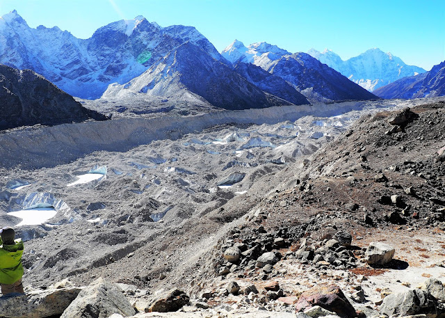
The Khumbu Glacier is located in the Khumbu region of northeastern Nepal between Mount Everest and the Lhotse-Nuptse ridge. With elevations of 4,900m at its terminus to 7,600m at its source, it is the world's highest glacier.

The Khumbu Glacier.

Yaks on their way to Gorakshep to re-supply essentials..

Rocks everywhere left by the retreating glacier.

Rocks everywhere left by the retreating glacier.

Rocks everywhere left by the retreating glacier.

The terrain is really rocky... fortunately... there is a sandy path that we can walk along.

Do I see stalactites?


The terrain is really rocky.

The terrain is really rocky.

And that is Gorakshep (5,164m )... the final checkpoint before Everest Base Camp.

Gorakshep is a frozen lake-bed covered with sand in Nepal, and also the name of the small settlement that sits at its edge at 5,164 m elevation, near Mount Everest. The village is not inhabited year-round.

The climbing isn't long, steep, or intense, but the elevation (and subsequent lack of oxygen) has seriously started to affect us.


Gorak Shep provides the best 'launching pad' for an ascent of Kala Patthar, which looks like a giant dune looming over the lakebed. For many trekkers, summitting Kala Patthar, with its 5,550 meters, provides both the best views of Everest and the highest altitude that most will reach without a climbing permit, which must be obtained in Kathmandu, at the Nepal Mountaineering Association.
Climbing starts in the early morning, when the visibility is usually better. It takes four hours to summit and come back. Gorak Shep was the original Everest Base Camp, being used by the Swiss mountain climbers in their attempt to climb the Everest in 1952. Later the camp was moved closer to the mountain, just below the Khumbu Ice Fall. Climbing time from Gorak Shep to the Everest Base Camp ranges from 1.5 to 2.5 hours, depending on the weather, acclimatization and physical conditioning of each individual. At this altitude, few people feel comfortable and many start to suffer symptoms of altitude sickness or acute mountain sickness (AMS).

That's Kala Patthar above Gorakshep (brown "dune").

Another bunch of buildings in Gorakshep not far from the first... There are birds here in Gorakshep... 5,164m above sea level...

Gorak Shep the last stop before Everest Base Camp and where most hikers spend the night before summiting Kala Patthar at sunrise.

The Yaks have arrived in Gorakshep.

The statue of Chatrapati Shivaji Maharaj unveiled at Gorakshep - the highest statue that is ever installed. The 2 solar water heaters in the center... The sun here is intense.


Our accommodation for the day... Yeti Resort Pvt Ltd.


Simon Loh in-front is seen half dead.

Amigo's first base camp!

Our iPhone is so accurate at 5,180m indeed.

Our small room in Gorakshep Yeti Resort Pvt Ltd..


Chicken soup for lunch... No appetite at all...

Simon is almost dead and yet wanted to go to Everest Base Camp... a horse is what it takes at US$120 for a round trip.

Then there was a sign that we were heading in the right direction.

We were heading in the right direction.

The long 3.5km walk to Everest Base Camp after lunch.

The long 3.5km walk to Everest Base Camp after lunch.

The rocky walk to Everest Base Camp.

Along the way, you get to see many of these monuments as remembrance.

Many have lost their lives to Mt. Everest... It makes you think why do people risk their lives, pushing themselves to their limit to conquer something much bigger than themselves...

The trek into base camp becoming a challenge to rock hop amongst the many large rocks that form part of the trail.

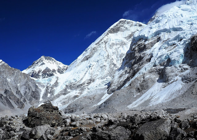
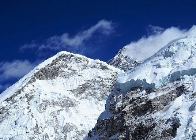
The final half is basically a straight ridge all the way to Everest Base Camp... You can see the Khumbu Icefall on the right already... If you follow the path of Khumbu Icefall up.. you will end up at Mt. Everest... Lingtren right in the center... Pumori on the left...

We have reached the end of the ridge... But this is not Everest Base Camp yet... Can you see Simon's horse right at the end...?

We still have to descend all the way down to reach Everest Base Camp... Can you see tiny people right in the center just below Khumbu Icefall... that's Everest Base Camp..

Simon's horse at the end of the ridge.

"The Khumbu glacier is one that forms the ice-fall and moves at such speed that large crevasses open with little warning, and the large towers of ice (called seracs) found at the ice-fall have been known to collapse suddenly. Huge blocks of ice tumble down the glacier from time to time, their size ranging from that of cars to large houses. It is estimated that the glacier advances 0.9 to 1.2 m (3 to 4 ft) down the mountain every day.
Most climbers try to cross the ice-fall during the very early morning, before sunrise, when it has partially frozen during the night and is less susceptible to movement. As the intense sunlight warms the area, the friction between the ice structure lessens and increases the chances of crevasses opening or blocks falling. The most dangerous time to cross the Khumbu Ice-fall is generally mid- to late-afternoon. Strong, acclimatized climbers can ascend the ice-fall in a few hours, while climbers going through it for the first time, or lacking acclimatization or experience, tend to make the journey in 10–12 hours. "Camp I" on Everest's South Col route is typically slightly beyond the top of the Khumbu Ice-fall.
On occasion, a climber will experience a large block of ice crashing down in their vicinity. The resulting blast of displaced air and snow can result in a "dusting" (the depositing of a billowing cloud of light ice and snow on the climber). To those that have experienced it, it is a very unnerving experience. If a climber is caught in an avalanche or other "movement" event in the ice-fall, there is very little they can do except prepare for potential entrapment by heavy blocks of ice or immediate movement afterwards, to try to rescue others. It is virtually impossible to run away or even to know which way to run.
Since the structures are continually changing, crossing the Khumbu Ice-fall is extremely dangerous. Even extensive rope and ladder crossings cannot prevent loss of life. Many people have died in this area, such as a climber who was crushed by a 12-story block of solid ice. Exposed crevasses may be easy to avoid, but some may be hidden under dangerous snow bridges, through which unwary climbers can fall."


Someone left her photograph here. The trail is not a smooth one and is filled with large boulders with the path being rocky and dusty and there is a dead drop right into the jagged and fatal glacier below.


Khumbu Icefall... Nuptse on the right... The Khumbu Icefall is an icefall located at the head of the Khumbu Glacier and the foot of the Western Cwm, which lies at an altitude of 5,486 metres on the Nepali slopes of Mount Everest, not far above Base Camp and southwest of the summit. The icefall is considered one of the most dangerous stages of the South Col route to Everest's summit. Everest is covered by the clouds beside Nuptse..


The Khumbu Icefall.

The Khumbu Icefall.

The Khumbu Icefall.

The Khumbu Icefall.

The trek into base camp becoming a challenge to rock hop amongst the many large rocks that form part of the trail.

The Khumbu Icefall.

The Khumbu Icefall.


The trek into base camp becoming a challenge to rock hop amongst the many large rocks that form part of the trail.

We finally reached the area of the base camp. We trekked across the rocks towards the many prayer flags that mark the spot. Celebrations and screams filled the air as the group reaches the spot that marks where base camp is.

The Everest base camp area is basically a big glacier mixed with rocks and a lot of dust. The size of the glacier is impressive.

Glacier is located in the Khumbu region of northeastern Nepal between Mount Everest and the Lhotse-Nuptse ridge. With elevations of 4,900 m at its terminus to 7,600 m at its source, it is the world's highest glacier.

Glacier is located in the Khumbu region of northeastern Nepal between Mount Everest and the Lhotse-Nuptse ridge. With elevations of 4,900 m at its terminus to 7,600 m at its source, it is the world's highest glacier.

Glacier is located in the Khumbu region of northeastern Nepal between Mount Everest and the Lhotse-Nuptse ridge. With elevations of 4,900 m at its terminus to 7,600 m at its source, it is the world's highest glacier.


Glacier is located in the Khumbu region of northeastern Nepal between Mount Everest and the Lhotse-Nuptse ridge. With elevations of 4,900 m at its terminus to 7,600 m at its source, it is the world's highest glacier.


Conquered...! Next stop... Raftel...! EBC is marked with piles of stones, dozens of strings of prayer flags, and a few “Everest Base Camp” signs with dates and elevation. In lieu of Everest, you get views of Lingtren (22,142 ft / 6,749 m), Khumbutse (21,867 ft / 6,665 m), and the Khumbu Icefall.

We were here: Everest Base Camp on 5 November 2017 @ 13:15

A dog in Everest Base Camp. If you come in May, Everest Base Camp is a tent city!

Everything that we have done... is for this moment at the Everest Base Camp, said Randy Ngatimin. Yes! Yes! We all truly agreed! However, we only completed half of the adventure... now to get back is another big problem, said Randy Ngatimin.

Congratulations to 'A' team: Alan Koh, Ong Teik Hong and Ching Neng Bin.

Congratulations to 'A' team: Alan Koh, Ong Teik Hong and Ching Neng Bin.

Congratulations to 'B' team: Simon Loh, Randy Ngatimin and Abdul Rashid.

Congratulations to the whole group at Everest Base Camp (EBC) 5,364m in the Himalayas. (L-R) Ching Neng Bin, Abdul Rashid, Simon Loh, Alan Koh, Prakash Kapri (guide), Ong Teik Hong, Randy Ngatimin and two porters infront; Binod and Rajendra.

Congratulations to the whole group at Everest Base Camp (EBC) 5,364m in the Himalayas. (L-R) Ching Neng Bin, Abdul Rashid, Simon Loh, Alan Koh, Prakash Kapri (guide), Ong Teik Hong, Randy Ngatimin and two porters infront; Binod and Rajendra.

Congratulations to the whole group at Everest Base Camp (EBC) 5,364m in the Himalayas. (L-R) Ching Neng Bin, Abdul Rashid, Simon Loh, Alan Koh, Prakash Kapri (guide), Ong Teik Hong, Randy Ngatimin and two porters infront; Binod and Rajendra.

Mr Alan Koh Seng Hock and Mr Ching Neng Bin representing SS14 Rukun Tetangga by carrying the banner to EBC. SS14 Rukun Tetangga is a newly set up group under the Department of National Unity and Integration for the neighbourhood of SS14 in Subang Jaya, Selangor.

Mr Alan Koh Seng Hock and Mr Ching Neng Bin representing SS14 Rukun Tetangga by carrying the banner to EBC. SS14 Rukun Tetangga is a newly set up group under the Department of National Unity and Integration for the neighbourhood of SS14 in Subang Jaya, Selangor.

Mr Alan Koh Seng Hock and Mr Ching Neng Bin representing SS14 Rukun Tetangga by carrying the banner to EBC. SS14 Rukun Tetangga is a newly set up group under the Department of National Unity and Integration for the neighbourhood of SS14 in Subang Jaya, Selangor.

Mr Ching Neng Bin representing the Malaysian Outward Bound Youth Association (MOBYA) by carrying the banner to EBC. To be completely honest, getting to Everest Base Camp is more about being able to say, “Yes, I have been to Everest Base Camp” than it is about seeing magnificent views or conquering altitude (although the landscape surrounding Base Camp is incredible).

Mr Ong Teik Hong and Mr Ching Neng Bin representing the Malaysian Outward Bound Youth Association (MOBYA) by carrying the banner to EBC.

Time to get back... up the horse for Simon Loh.

The trail back to Gorak Shep. Once the celebrations was over as well as all the photo taking, we start to head towards Gorak Shep for the evening. Thinking about the the next day 4am trek up Kalapatha to see the sun rise over Everest.

We arrived at our the Yeti Lodge at 4.45pm.

Back at the Yeti Lodge.

Back at Gorakshep Yeti Lodge at 4.45pm and dinner at 5.30pm. Everyone is dead tired.

Look at Ching's left toe nail that turned black after 8 days of trekking 65km from Lukla up to Everest Base Camp. The toe nail would be replaced in a few months time.
click below to view:
EBC trek Day 01 (28.10.17) – Kuala Lumpur KLIA to Kathmandu (1,334m/4,375ft)
EBC trek Day 02 (29.10.17) – Kathmandu fly to Lukla (2,865m) and trek 8km to Phakding
EBC trek Day 03 (30.10.17) – Phakding trek 10.4km to Namche Bazaar (3,445m/11,299ft)
EBC trek Day 04 (31.10.17) - Acclimatization day at Namche Bazaar (3,445m/11,299ft)
EBC trek Day 05 (01.11.17) - Namche Bazaar trek 10km to Deboche (3,867m/12,684ft)
EBC trek Day 06 (02.11.17) - Deboche trek 10km to Dingboche (4,412m/14,471ft)
EBC trek Day 07 (03.11.17) - Acclimatization day at Dingboche (4,412m/14,471ft)
EBC trek Day 08 (04.11.17) - Dingboche trek 12km to Lobuche (4,931m/16,174 ft)
EBC trek Day 09 (05.11.17) - Lobuche 8km to Gorakshep trek to EBC (5,364m/17,595ft)
EBC trek Day 10 (06.11.17) - Gorakshep to Kalapattha and fly back to Kathmandu
EBC trek Day 11 (07.11.17) - Kathmandu 'The Good, the Bad and the Ugly’
SJ Echo - the Subang Jaya's FREE community newspaper
///
No comments:
Post a Comment